Join Darlene Liss, volunteer Forest Ambassador, on Wednesdays at the Maroon Bells Visitor Center for hands-on exploration
of wild things.

Take the Forest Conservancy Conservation Pledge to earn a Smokey Bear Junior Ranger pin.

 
DO YOU LIKE TO SHOP?
Click here to find out how you can support
the Forest Conservancy while you shop!
about us   |   volunteering   |   find a trail   |   e-naturalist cafe   |   quick links
Columbines
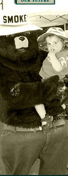
Smokey Bear educates the public about preventing forest fires.
SNOWMASS LAKE #1975
Back to the trails list

 
Trail: Snowmass Lake #1975
Region: Old Snowmass area
Difficulty: difficult
Description: From the parking area the trail climbs into the aspen trees behind the information board. The trail climbs on the east side of Snowmass Creek for about 6 miles. It continues above and to the left of a large beaver pond and soon crosses Snowmass Creek at a second beaver pond. Sandals are recommended for this stream crossing. You will most likely get wet. The trail then continues south climbing several switchbacks before entering the forest. As the trail levels you will come to a wooden sign post. Continue straight ahead to get to Snowmass Lake. Take the left fork to remain on the Maroon-Snowmass Trail or to find the large group and campfire sites. Continue on the Maroon-Snowmass trail to another signed junction. Stay left (going right will put you on the Geneva Lake trail and will also return you to Snowmass Lake). The trail descends through forest and crosses Snowmass Creek. The trail ascends into the valley and begins a steep climb to Buckskin Pass. From the top of Buckskin Pass the trail drops steeply into a vast alpine meadow (please, no camping in the meadows). The trail continues through the meadow to a sign for the Maroon-Snowmass/Willow Lake junction. Take the right fork to continue on the Maroon-Snowmass Trail. The trail descends steeply through Minnehaha Gulch which provides excellent camping (remember, your site must be 100 feet from the trail or stream) then continues its steep descent to the junction at Crater Lake. You can camp in designated sites at Crater Lake or continue to the left towards Maroon Lake. From Maroon Lake you can catch the bus back to Aspen before 5:00 PM. between mid June- September. Otherwise you will have to make other arrangements to get back into Aspen.
Directions: From Aspen, drive 6 miles west on Hwy 82 and turn left on Brush Creek Road. Continue 5.5 miles and turn right on Divide Road - turns into gravel road and passes Krabloonik. The road descends steeply to valley bottom and then forks; take the left fork an
Map: USGS Maroon Bells, Snowmass Mtn, Capitol Peak


Home  |   About Us  |   Volunteering  |   E-Naturalist Café  |   Support the Forest Conservancy  |   Contact Us  |   Site Map
THE FOREST CONSERVANCY • 1012 Brookie Drive, Carbondale, CO 81623 • 970-963-8071

Site Design by: Unleashed Designs