Join Darlene Liss, volunteer Forest Ambassador, on Wednesdays at the Maroon Bells Visitor Center for hands-on exploration
of wild things.

Take the Forest Conservancy Conservation Pledge to earn a Smokey Bear Junior Ranger pin.

 
DO YOU LIKE TO SHOP?
Click here to find out how you can support
the Forest Conservancy while you shop!
about us   |   volunteering   |   find a trail   |   e-naturalist cafe   |   quick links
Columbines
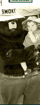
Smokey Bear educates the public about preventing forest fires.
SCHOFIELD PASS ROAD #317
Back to the trails list

 
Trail: Schofield Pass Road #317
Region: Crystal River Valley
Difficulty: difficult
Description: Schofield was an old mining town and is now a ghost town with a number of old buildings still standing. The first portion of the road passes through a narrow, steep canyon which contains a number of picturesque water falls. The Devil's Punch bowl is a series of water falls ending in a deep pool of water. Schofield Park is large and open and is surrounded by the majestic peaks of the Elk Range. The East Fork trailhead into the Maroon Bells-Snowmass wilderness can be accessed on this road. This road will connect to roads leading to Crested Butte during the Summer. This route should only be attempted by very skilled and experienced four-wheel drivers, and only in jeep-type, small, high clearance 4WD vehicles. There have been several fatal accidents on this road. Most accidents occur on the descent from Schofield Park to the Devil's Punchbowl. One danger is drivers not drying out their brakes after a deep creek crossing before the steep descent. A snowbridge, formed by winter avalanches, crosses the road about halfway between Crystal and Schofield Park. During some years the snowbridge does not melt sufficiently to allow passage. The segment from Schofield Park to Schofield Pass is easy, as is the drive from the pass to Crested Butte. The entire route is popular with hikers and mountain bikers as well as 4WD enthusiasts.
Directions: From Carbondale travel south on Highway 133 about 22 miles to the Marble turn-off and veer left onto road #314. Go east on the Marble road, through Marble and past Beaver Lake. The road begins to head uphill and passes over shale rock. About 1 mile outside of Marble there is a fork in the road; take the right fork. The road immediately heads downhill, then on to Crystal City. After Crystal City take the right fork onto road #317 to reach the pass.
Map: Snowmass Mountain, Oh-Be-Joyful, Gothic


Home  |   About Us  |   Volunteering  |   E-Naturalist Café  |   Support the Forest Conservancy  |   Contact Us  |   Site Map
THE FOREST CONSERVANCY • 1012 Brookie Drive, Carbondale, CO 81623 • 970-963-8071

Site Design by: Unleashed Designs